AtlasHistory of Territory and GovernanceTobias Etter and Oluwasegun Ogunsola
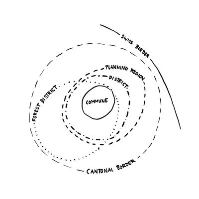
The role of administrative borders and subdivisions has waxed and waned throughout the history of Zurich and of Switzerland as a whole. The early alemannic settlements that build the basis of many of todays villages and cities spread across present-day cantonal and national boundaries. As their etymology suggests, they were mostly centred around individuals or small groups of people. Today, we have legally defined communal and district borders. These, however, are far from static: Dozens of communes have merged or been amalgamated over the last century, as a response to factors such as urban sprawl, increasing complexity, efficiency and the costs of administrating such a municipality. The communal borders still pose a source of local identity for many, as evidenced in some communes’ slogans (e.g. Maschwanden - “Wir wollen ein Bauerndorf bleiben”). However, several communes and local organizations have seen the need to look beyond administrative borders when planning the present and the future. One example is the “Limmatstadt”, a planning region that spans district and cantonal borders.
Toponymy
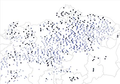
Spread of place name suffixes throughout german-speaking Switzerland. The suffixes suggest three distinct phases of alemannic settlements. Source: swissNAMES3D
- -ingen suffix: earlier alemannic settlements
- -ikon suffix: first medieval expansion of alemannic settlements
- -wil suffix: second expansion of alemannic settlements
Most of the place name suffixes in the German-speaking part of Switzerland are of Alemannic origin. The spread of these suffixes can tell us a little about the history of these places. Place names ending with -ingen are among the earlier alemannic settlements. The suffix -ikon (" was predominantly used for extensions of settlements built in the 7th and 8th centuries. Later agricultural settlements tend to have the ending -wiler. Sources: Historisches Lexikon der Schweiz, Aargauer Zeitung
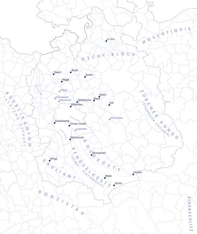
Map of informal names for selected regions, cities and areas around the Canton of Zurich. Source: Züri-Slängikon
There are different categories of informal names used for towns, cities and regions. They can range from simple abbreviations (“Wädi” for Wädenswil) to wordplay (“Dameschwinge” for Schwamendingen). Some informal names, however, can give insights into a place’s topography (“Pfnüselküste”), history (“Göhnerswil”), economy (“Mostindien”) or its perception by others (“Gwaltstette”).
The Limits of Borders
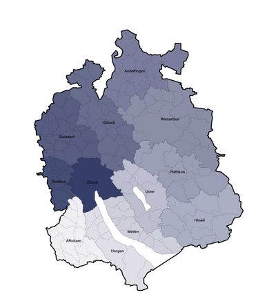
Subdivision into cantons, districts and communes – it is the basic division of Swiss democracy. The judiciary follows exactly this pattern with the federal, cantonal and district court up to the magistrate at community level.
source: districts of Zurich
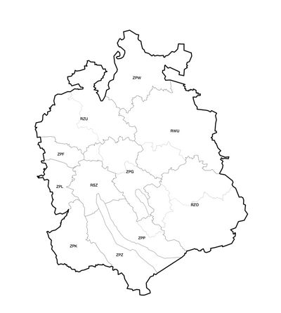
Superimposition of the planning regions in relation to the districts in the canton of Zurich. Source: Planning regions.
 Planning Regions
 Districts (Bezirke) of Zurich
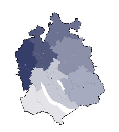
Superimposition of the forest districts and planning regions in relation to the districts in the canton of Zurich. Source: forest districts.
- forest district 1
- forest district 2
- forest district 3
- forest district 4
- forest district 5
- forest district 6
- forest district 7
 Districts (dotted line)
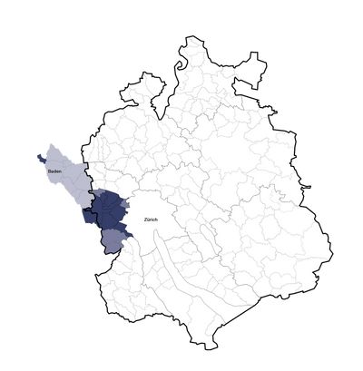
The “Limmatstadt” is an independent planning region between the cities of Zürich and Baden. It is contractually bound to a group of communities and many organizations and companies are involved. It differs from the previous maps above all in its different composition and the supra-cantonal work.
source: “Limmatstadt”
- municipalities with contract: Bergdietikon, Dietikon, Geroldswil, Schlieren, Turgi, Uitikon, Unterengstringen, Urdorf, Weiningen
- through the accession of the ZPL in the "Limmatstadt", most recently joined communities: Aesch, Birmensdorf, Oberengstringen, Oetwil
- municipalities with a connection to the Limmat River
The division of Switzerland into cantons, districts and communes dates back to the 19th century. It is closely linked to our political system. Nevertheless, the borders are adjusted at the municipality or even canton level in order to reduce the administrative burden or to adjust the affiliation. Within the cantons there are further subdivisions for forest, settlement, traffic, supply and disposal. It is not possible to draw a line that respects each subject, so we are constantly forced to think beyond the borders.
Communal Borders Throughout History

Mergers and amalgamations in the Canton of Zurich since 1893. Source: Amtliches Gemeindeverzeichnis.
- New border of merged/amalgamated commune
The modern political commune came into being during the Helvetic period (end of the 18th century). In the late 19th and early 20th century, the cities of Zurich and Winterthur amalgamated several surrounding communes. Since 2014, there has been a wave of communal mergers. Communes with small populations struggle to find the necessary human and financial resources needed to fulfil their duties. Merging two or more communes is seen by some as a necessary step to create more efficient, functioning municipalities. However, the concept of communal autonomy and the importance of local identity are common sources of friction when it comes to the discussion of mergers.
Votes
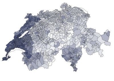
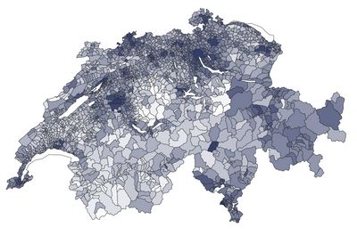
Election: Fair-Food-Initiative
Again and again there are votes that represent the cliché of the “Röstigraben”. Another example would be voting on EEA accession.
source: Politatlas
- 100% yes vote
- 80% yes vote
- 60% yes vote
- 40% yes vote
- 20% yes vote
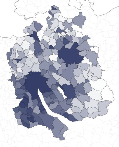
Election: Trinkwasser-Initiative
Another stereotype is the urban-rural divide.
Source: Politatlas
- 100% yes votes
- 80% yes votes
- 60% yes votes
- 40% yes votes
- 20% yes votes
Election: Energiegesetz
Depending on the proposal, none of the usual boundaries can be identified.
source: Statistik App ZH
- 100% yes votes
- 80% yes votes
- 60% yes votes
- 40% yes votes
- 20% yes votes
The vote on the “Energy Law” shows the inaccuracy of political borders and clichés. Especially in the communities that have voluntarily joined forces to plan the Limmatstadt, there seem to be major differences when it comes to sustainable energy. The three maps shown are not even 5 years apart and all have a different pattern.
Political Parties: Going Green

Political party with highest percentage of votes in national elections per commune. Source: Bundesamt für Statistik.
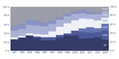
If only the parties with the strongest votes in the canton of Zurich between 1975-2019 are shown, there is an extreme reduction to 5 parties on the map. What is special is that strong parties such as GLP (Green Liberal Party) and GPS (Green Party) do not appear.
Compared to the other maps in the “History of Territory and Governance” section, the maps for parties and electoral voters are relatively quick to change. This is of course due to the free “emergence” without change of law or boundary stones.
