AtlasThe Built and the UnbuiltSebastian Baumann and Ryusei Murata
Over the last decades the population has grown, the industries evolved and the needs and dreams of the citizens changed. In consequence, the land use in the Canton of Zurich has been transformed on different scales and the built and unbuilt areas have been reshaped. Most of the territory in Zurich is situated on a convenient height above sea level for land use. Insofar, together with the ongoing process of population growth, the changes have mainly been in favor of settlement areas. Because the unproductive area consists mainly of water and their extent has hardly changed and, as well, the forest in Switzerland is strictly protected, the settlement areas expand mainly at the expense of cultivated land. This process isn’t ongoing in the same way near the city center as in areas with the character of a village or suburbia. As you go away from the center of Zurich, the functions of the built are getting more and more separated with less zones of mixed use and lower buildings in residential zones.

How Land Use Goes with Swiss Topography?

The topography of Zurich with certain altitude
Legend
 500m
500m 800m
800m 1200m
1200m
- 500m
- 800m
- 1200m

Land use of Switzerland. Source: L’utilisation du sol : hier et aujourd’hui, Statistique suisse de la superficie, Neuchâtel 2001.

Land use of Switzerland. Source: L’utilisation du sol : hier et aujourd’hui, Statistique suisse de la superficie, Neuchâtel 2001.
- Wodded land
- Agricultural land
- Living area and surfaces
- Unproductive surfaces


Most of the territory in Zurich is situated below 500 m and little are higher than 1000 m which is still convenient for land use.
The Built and the Unbuilt
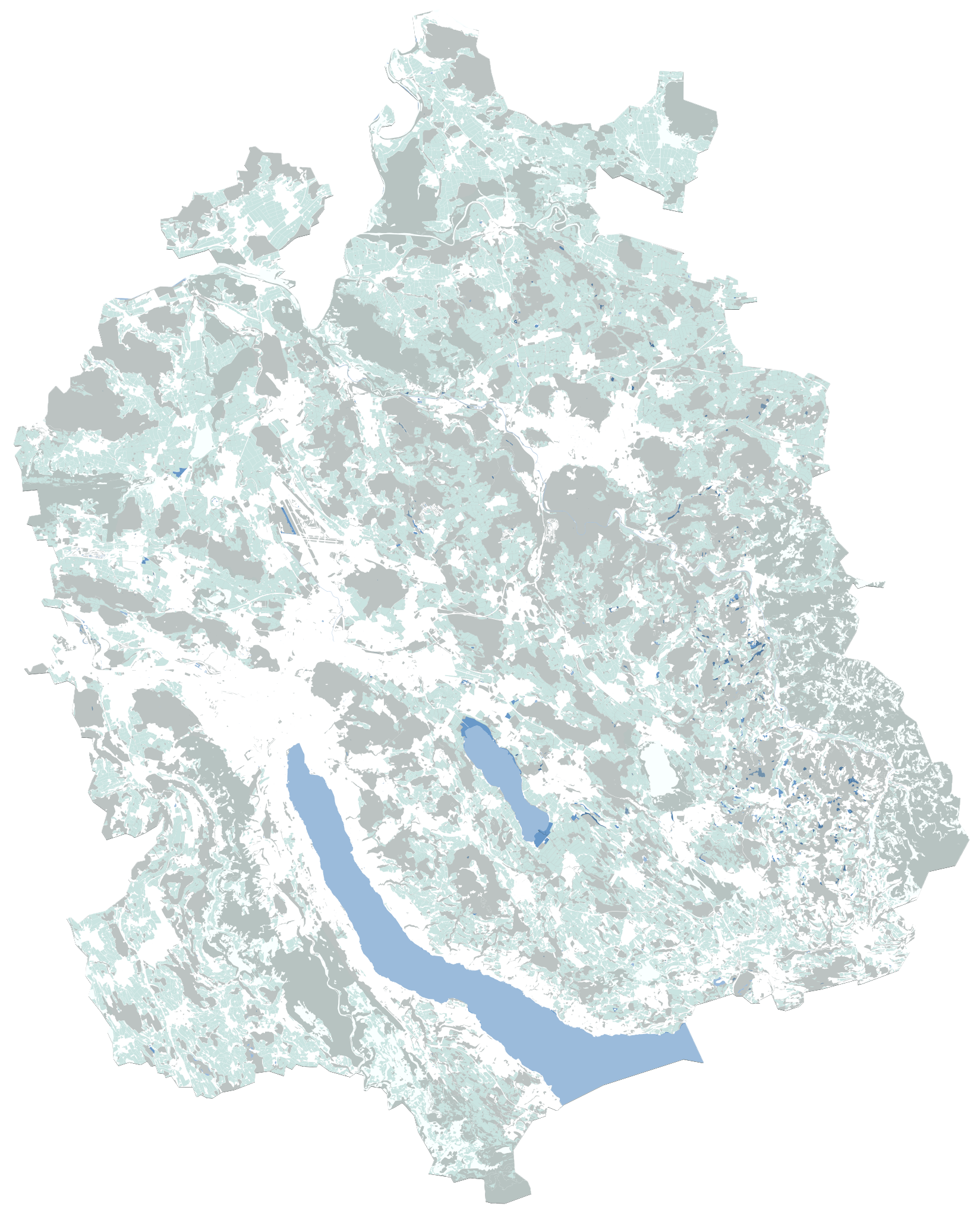
The built and the unbuilt areas In 2020.
Building land in the Canton of Zurich is surrounded by agricultural land and forest. 30 percent of them are forested, around 41 percent of the canton’s area is used for agriculture, and 6 percent is unproductive area – mostly lakes, watercourses and wetlands. Around a quarter of the total area is used for settlement purposes which makes the canton of Zurich one of the settlement centers in Switzerland. Bodennutzung Kanton Zürich.
How People Change Land Use? from Agriculture to Infrastructure.

Change of land use between 1936-2017. Source: Raumplanung Zürich.
- Agriculture surface
- Woodland
- Water surface
- Settlement area
The settlement areas expand; the unproductive area consists mainly of water, and their extent has hardly changed, at least in recent times. Because the forest in Switzerland is strictly protected, the wooded areas are also practically unchangeable. Therefore, the settlement areas expand mainly at the expense of cultivated land.


Urban fabric extension over the last 200 years.
- 1800-1850
- 1850-1900
- 1900-1920
- 1920-1940
- 1940-1960
- 1960-1980
- 1980-2000
- 2000-2020

Population growth of Zurich. Source: Statistik Stadt Zürich.
- Lower Scenario
- Medium Scenario
- Upper Scenario


The number of houses in Switzerland gradually increased not only in the center of Zurich but also in the agglomeration. The different scenarios of the population growth implicit either a densification of the built surfaces or further building on unbuilt areas.

Analyse of the functions. Source: GIS Quartieranalyse.
- Zones of mixed use
- Housing below 3 stories high
- Housing higher than 3 stories
- Industrial zones
As you can see from the map, there is not a big difference between city area and rural area. The both sides has multifunctional buildings, therefore you can’t tell building typologies from this map. However, compared with the maps of urban fabric expansions, you can see the gradual changes from past and see the transition of some regions, from a village to a city.
We can conclude that each region found a way to exist as a village or a city.