AtlasHydroNora Hauser, Leonie Mischler, and Andela Pejic
Hydropower, the use of a hydroelectric generator to convert the potential or kinetic energy of water into mechanical work, is considered a renewable energy source in Germany. In the region of the Rheinland, the Rur is one of the few sites of hydro-electrical power production. River dams with hydroelectric power stations or run-of-river power stations are examples for this technology in the region. In addition to producing energy, they regulate the flow of the river and can prevent from flooding. Nevertheless, river dams with hydroelectric power stations or run-of-river power stations interfere massively with river ecosystems. The unique landscape of the Rur watershed is affected by this as well.
There is another type of water management in the region which is far more invisible: the regulation of the groundwater level by the brown coal mining firm RWE. To prevent groundwater from entering their three mines in the region, Inden, Hambach and Garzweiler, they pump the water up to 450 metres up. This groundwater pumping causes several problems in the surrounding area such as lower ground water levels which effect wetland ecosystems and the lowering of the ground level.

Human-Shaped Water Landscapes
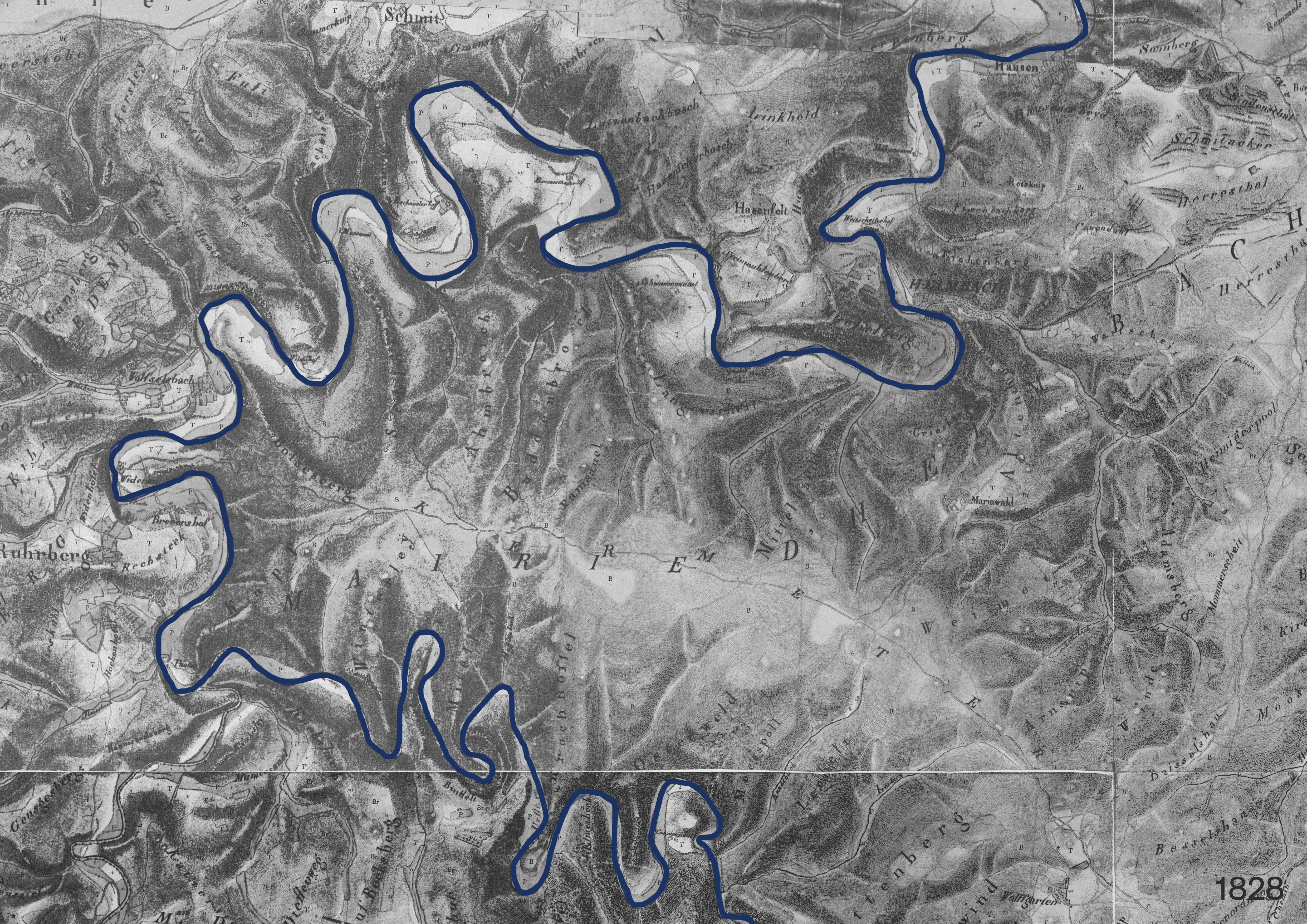
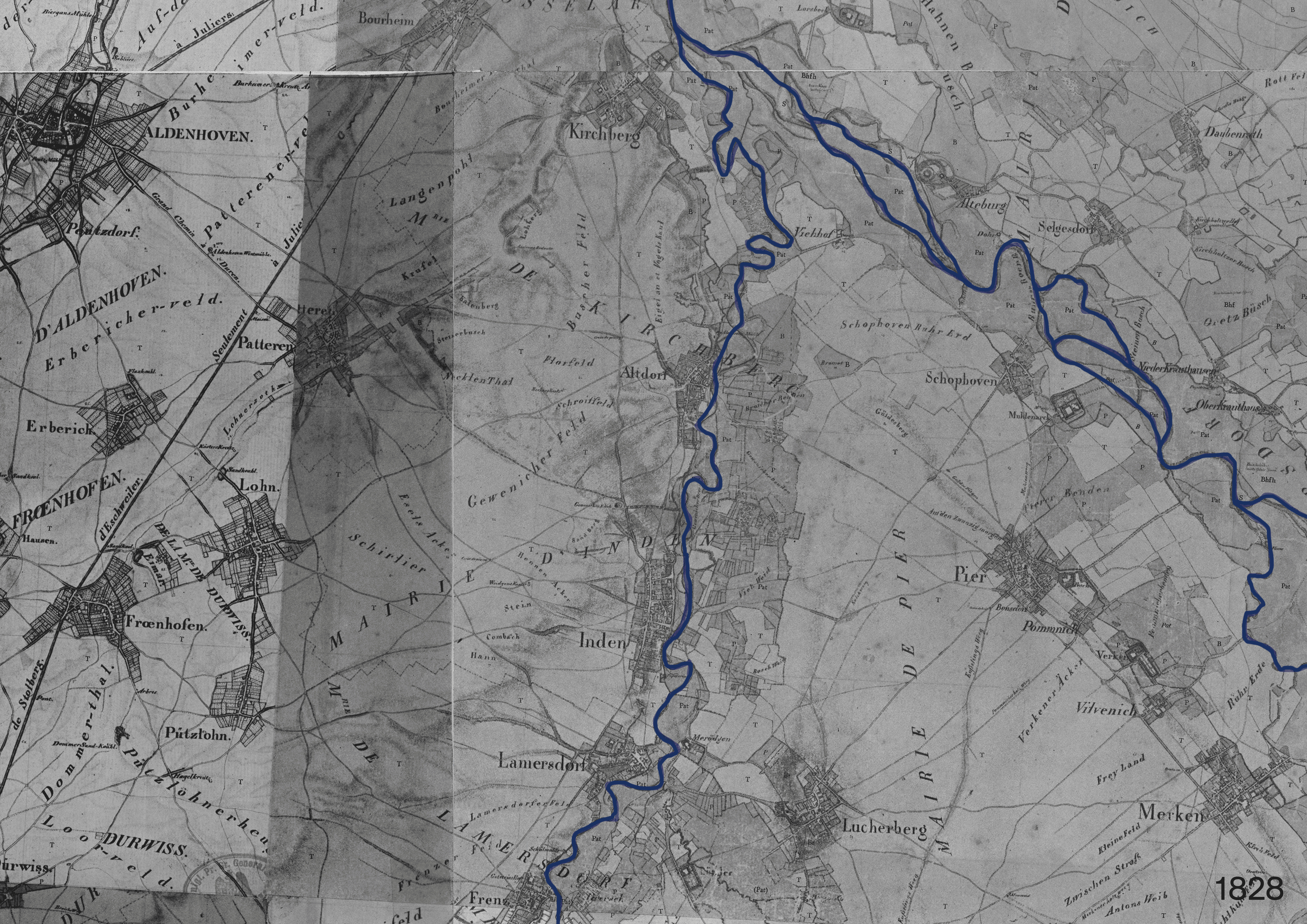
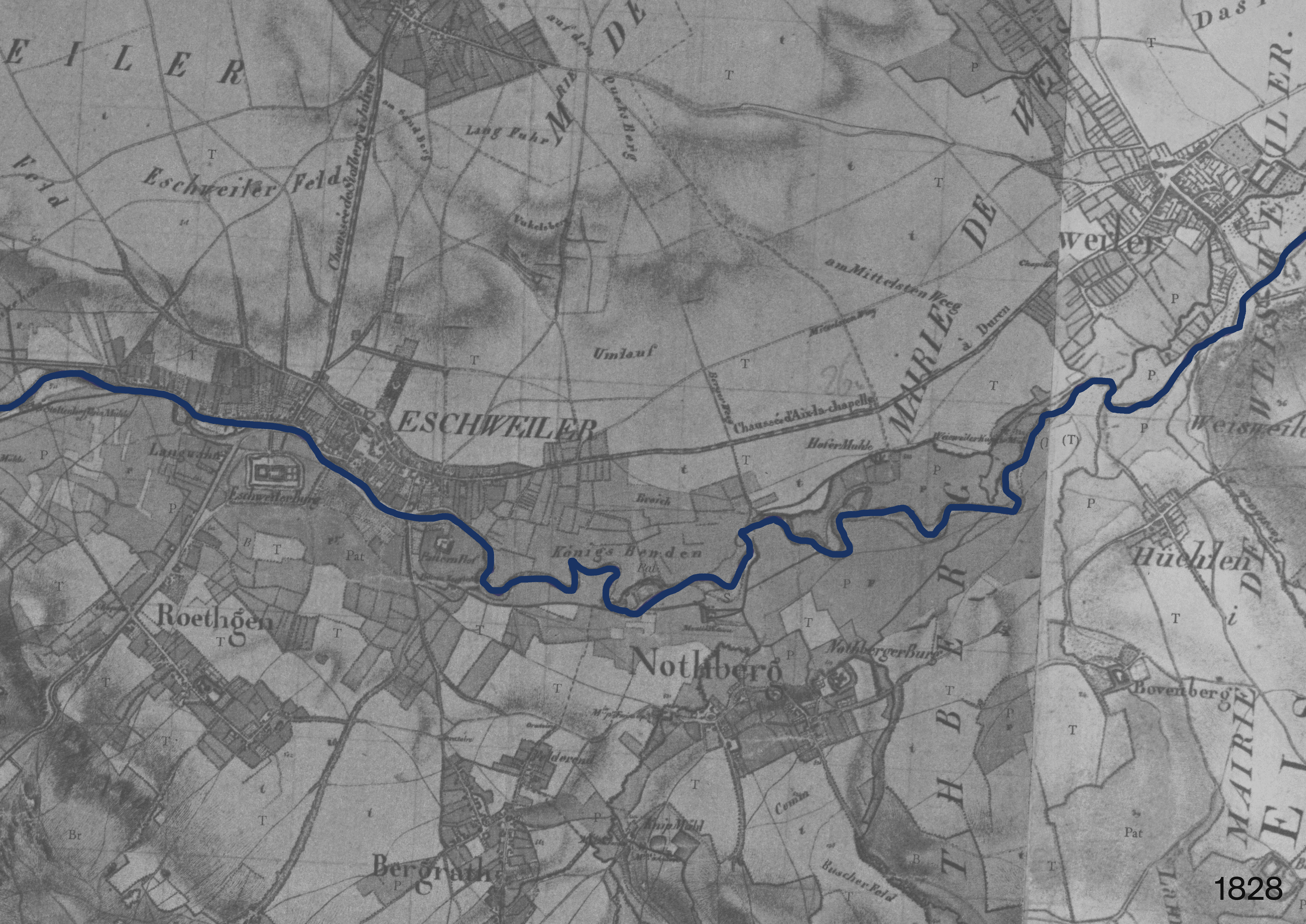
The majority of European river courses have changed significantly and irrevocably over the past 200 years. These alterations are related to many anthropogenic uses and exploitations of rivers including rafting, running water mills, large-scale hydroelectric power plants, industrial water withdrawal, and flood control methods. These changes in the water landscape have far-reaching consequences for the entire river course. This means, for example, that a dam on the Urft in North Rhine-Westphalia can have an impact on the water quality of the North Sea.
Source:TIM-online
Source:TIM-online
Source:TIM-online
Humans have shaped the water landscape in the Rur watershed constantly. In the course of time, there have been three different types of transformations: Firstly, dams were constructed to expand the river bed and thereby collect drinking water and prevent from flooding. Secondly, rivers were straightened for flood protection and to gain arable land. Thirdly, rivers have been rerouted to make place for the brown coal mining.
Large Infrastructure—Small Energy Production

Source: Statistisches Bundesamt (Destatis)

Source Germany: Statistisches Bundesamt (Destatis)
Source Switzerland: Bundesamt für Energie BFE
In 2021 around 3 % of the gross electricity generated in Germany came from hydroelectric power production. Compared to other renewable energies such as wind energy or photovoltaics, water energy plays a relatively small role in energy production.
A national comparison between Germany and Switzerland, that produces 60 % of the gross electricity with hydropower thanks to its topography and considerable average precipitation, shows that Germany generates little energy production from hydropower.

In the Rur watershed, there are two types of hydroelectric power plants: The run-of-river hydropower plant and the storage hydropower plant. There are significantly more run-of-river hydropower plants, which have a much lower electricity production than the storage hydropower plants.

NUMBER OF HYDROELECTRIC POWER PLANTS IN NORDRHEIN-WESTFALEN AND THEIR POWER IN MW DIVIDED BY PERFORMANCE CLASS AND POTENTIAL 2017
Source: Landesamt für Natur, Umwelt und Verbraucherschutz Nordrhein-Westfalen
Legend
 Number of hydroelectric power plants
 Power Production in MW
 Number of hydroelectric power plants
 Power Production in MW
- Number of hydroelectric power plants
- Power Production in MW
- Number of hydroelectric power plants
- Power Production in MW
There are many more run-of-river power plants not only in the Rur watershed, but also throughout North Rhine-Westphalia. These make up the largest part of the hydroelectric power plants, but produce less than 20 % of the energy produced by hydroelectric power. In contrast, the larger storage hydroelectric power plants, of which there are far fewer, produce 80 % of the energy. Consequently, run-of-river power plants can be considered inefficient.

POTENTIALS OF HYDROELECTRIC POWER IN THE RUR WATERSHED REGION
Source: Landesamt für Natur, Umwelt und Verbraucherschutz Nordrhein-Westfalen
Legend
 DÜREN: 1'150 kW
 HEINSBERG: 530 kW
 EUSKIRCHEN: 240 kW
 STÄDTEREGION AACHEN: 0 kW
- DÜREN: 1'150 kW
- HEINSBERG: 530 kW
- EUSKIRCHEN: 240 kW
- STÄDTEREGION AACHEN: 0 kW
North Rhine-Westphalia’s (NRW) hydropower potential is already largely exhausted, leaving the state only to expand existing hydropower plants. Scenarios pertaining to aquatic ecology and legal requirements show a hydropower potential of just about 14.4 MW in North Rhine Westphalia’s (NRW). Breaking it down to the Rur Watershed this potential decreases down to approximately 1,9 MW.
Height over Volume: Different Forms of Hydroelectric Power Production


Hydropower os generated through the flowing movement of water. Water passes through a turbine. Due to the pressure generated by the flowing water, the turbine rotates and transmits the kinetic energy to a generator. This is where mechanical energy is transformed into electrical energy. The it is passed to a transformer from where the electricity is fed into the network and distributed.
Two main factors are relevant for the amount of energy that can be generated by a hydroelectric power plant. One is the water mass and the other is the flow velocity. In order to keep both values as high as possible, the greatest possible drop height must be generated within the system. The drop height is defined by the difference in height between the upper edge of the backwater and the upper edge of the tailwater: the water level upstream and downstream of the hydropower plant. Two types of hydroelectric power plants are common, which have their biggest difference in the way how they generate this drop height: the storage hydropower plant and the run-of-river power stations
The storage hydropower plant uses stored water for the production of energy, which has to be dammed in the course of the river. It results in a reservoir on a higher level upstream of each storage hydropower plant. Thanks to the damming, most of these systems have a large drop height. The amount of water stored can vary greatly. The dammed water is pressed through a penstock down to the turbine. With the help of this pressure pipe a high flow velocity in combination with a large water quantity can be produced. Such hydroelectric power plants can be built only in places with strong topography.
Run-of-river power stations are located directly in the course of the river and use the natural flow of the river directly. The water flows unimpeded through the turbine without the addition of a pressure pipe. The drop height in this system is low and therefore the flow velocity of the water is low. Therefore, no strong topography is necessary for the construction.

On the basis of three examples within the watershed of the Rur, the different characteristics as well as the footprint of hydropower plants are examined in more detail. Two different types of storage hydroelectric power plant as well as a run-of-river power plant are compared. The Olef River Dam is located south in the watershed and sources its energy from the Olef River. Further downstream, the Olef River flows into the Urft River, where the Urft Dam and its associated Heimbach power plant are located. Following the river further north, the Winden run-of-river power station is located in the outskirts of the city of Düren.


Among the three examples the amount of electricity produced varies greatly. The Winden run-of-river power station produces the least energy. With less than 100 KW it is a mite compared to the two dams. This is due to the the low drop height, which is less than 2.5 metres. In comparison, the Olef River Dam, designed as a storage hydropower plant, produces 3 MW thanks to a drop height of 53 metres. The drop height of the Urft dam is at 110 metres, and 16 MW, are generated, due to a penstock through the adjacent mountain to the tailwater of the Rur. This elaborate system makes this hydropower plant the largest in the watershed.
The Winden hydropower plant does not have a reservoir and therefore does not really have a specific footprint. The length of the headwater is titled 550 metres, where the water has to be controlled for the proper functioning of the power plant. On these distance the river can flow unchecked. A slight backwater is nevertheless noticeable for nature and influences the natural conditions. The reservoir of the Olef dam, with a size of 19.3 million m3 of storage space, is considerable and meander far through the existing valley mountains. The storage basin of the Urft dam is even larger and contains 45.51 million m3 of water when fully dammed. The footprint, and thus the immediate spatial impact on nature, of the storage power plants is immensely larger than that of the small run-of-river power plant.

The Urft dam was completed in 1905 and was the largest dam in Europe at that time. It was originally built because agriculture and the cultivated area near the river were in need of regulation. Since building along to the water is not unusual at this time, some settlement structures must be destroyed for the construction of the reservoir. Nowadays only the tip of the village of Krummenauel protrudes from the surface of the reservoir as a small island. Today, the entire shore is characterised by dense forestation. Settlement structures are almost nonexistent. The lake is located in the middle of the Eifel National Park and is embedded in a vibrant natural landscape.

Between 1954 and 1959, the Olef River Dam was constructed to provide drinking water as well as flood protection for the nearby municipalities. The dam was formally opened in 1965, when the valley was submerged entirely for the first time. Raising low water levels, industrial water processing and hydropower generation are additional uses of the dam. The concrete pier-cell dam is architecturally unique in Germany. It’s location is near the Eifel National Park in Hellenthal. Around the Olef river runs a circular path of 13.5 km, which offers a source of recreation.

The river power plant Winden is a strip weir and is located on a slope in the course of the river. This results in a slight widening around the structure. The structure is classified as in need of major rehabilitation and as an obstacle to the passage of target species. There is no so-called fish ladder, which is supposed to facilitate fish passage. The structure is located at the southern edge of Düren on the watercourse of the Rur. The surrounding area presents itself with a mostly flat topography and only one-sided forestation. Close to the course of the river there is a dense settlement area.
Conclusion
The analysis of the different types of hydropower plants in North Rhine-Westphalia shows that only the small run-of-river power plants have been built with the aim of producing energy. All storage hydropower plants in the region are mainly built for water regulation where energy production is only a by-product. Their impact on the river habits is nevertheless massive, which makes their usefulness questionable.
How Fossil and Nuclear Energy Production Steal Our Water

Source: Statistisches Bundesamt (Destatis)
In Germany, the water consumption can be divided into two sectors: The industrial sector (69 %) and the public water supply (31 %). Most of the water used for the industrial sector is used for the cooling of coal, gas, or nuclear power plants. In Germany, these power plants account for 46 % of water use, consuming more water than any other industry. Therefore, the production of fossile and nuclear energy have far-reaching consequences on the water balance.
The nuclear power plants evaporate only part of the cooling water, the rest of the water is purified and returned to the river systems slightly warmed. Water ecosystems react very sensitively to this change in temperature. There can be lower oxygen levels and certain fish species are impaired in their reproduction or die prematurely. Due to climate warming, more and more heat waves can be expected in Germany. This will potentially lead to restrictions on nuclear power plants in order not to increase the heating of the waters even further, as was already the case in the hot summer of 2003, when several power plants had to reduce their output. The same problem occurs in France: Because of the 2022 energy crisis, the government decided to grant a special permit to allow rivers to get warmer in order to secure the power supply. Conservationists fear for the life of the fish in the rivers.
One of the biggest energy sources in Germany is the brown coal. Its mining does not only consume great quantities of water but has drastic changes on the existing groundwater level: to prevent water from entering the mine, the groundwater needs to be pumped up.
Lowering the Groundwater Level for Mining

.
Before the brown coal can be extracted, the groundwater must be lowered over a large area. The soil is also dewatered during the operation to prevent groundwater from seeping into the open pits. In a first step, boreholes are drilled and wells are set up, which are connected by pipelines and power cables. Then the actual dewatering can begin. In this process, a motor pump pumps the water to the surface and into the pipelines. The deepest wells now reach up to 450 metre below ground.


The pumping network operates around 1,500 wells with a total of 800 kilometres of risers to keep the open pit mines dry. In the process, a total amount of 580 million cubic meters of water are extracted from the various groundwater levels. As the open pit mine migrates and also grows in size, 40 kilometres of new pipelines and power cables are laid each year and even more pipelines get rerouted. The employees of the network construction thus work on the constant set-up and dismantling of the extensive pipe and cable network, which has a total length of around 750 kilometres.
The largest part of the network is invisible underground. The individual pumps that come to the surface, however, shape the landscape and give a glimpse of the large-scale network underneath.
EXTRACTED GROUNDWATER


Once pumped out, the extracted groundwater is used for different purposes, such as drinking water, wetland infiltration, power plant cooling. The remaining water is discharged into rivers and streams in the region.
Drinking water
About 40 of the 580 million cubic meters of groundwater pumped each year are treated into drinking water at four waterworks. Groundwater is generally not meant for drinking. Therefore, substances such as iron and manganese, which occur naturally in the groundwater in the Rhineland, are filtered out in the drinking water plants. The treated water is then supplied to various municipalities in the region.
Wetland infiltration
Extracting the water from the ground extremely dries out the surrounding soil of the open pits. For this reason, around 70 million cubic meters of the water are treated and then used to rewet the soil. This is intended to safeguard the habitat of animal and plant communities that have become rare and are therefore worthy of protection.
Service water for brown coal mining
Around 190 million cubic meters of groundwater are used as so-called service water in the brown coal power plants. As thermal power plants, they need the water from the open pit mine to cool the power plants. On the other hand, the pumped-up water is used for sprinkling the open pit mines so that the dust formations inside the mines cannot spread to surrounding areas.
Back to the river
The remaining 280 million cubic meters of groundwater are discharged into rivers and streams in the region. The aim is to ensure that the ecological balance of the rivers is not disturbed.

The consequences of the dewatering of the open pit mines are far-reaching. Not only the immediate areas around the mines are affected, but a funnel is created, which lowers the groundwater level of the entire region. Springs dry up and wetlands with a high biodiversity are threatened to get dry and therefore have to be constantly irrigated artificially. Groundwater quality is also deteriorating, as iron and sulphates enter the water as a result of the mining and turning the water into acidic water.
“Coal-fired power plants not only fuel climate change, they rob us of our most precious resource—water.” (Karsten Smid, Greenpeace expert on energy)
What happens after the mining stopes? Groundwater levels will take decades to return to normal, which will lead to new problems: the rising ground water will release more iron and sulphates into the water, and the environment can be damaged with the acidic water. Other heavy metals such as mercury, which were spoilt in the open pits, may also enter the groundwater and might lead to water logging of the soil in settlement areas. Other consequences are currently unforeseeable today, but might occur in the future.
Long Lasting Impacts of Water Control
Dams, transverse structures, river straightening and rerouting, as well as pumping groundwater and discharging heated water from nuclear power plants into rivers have all far-reaching negative consequences for the territory. Especially the small run-of-river power plants, which produce little energy, have proportionally a highly negative impact on the river landscape. The pumping out of groundwater, which is actually only a by-product of brown coal extraction, also has far-reaching effects on the entire region. Not only nature and animals suffer from these consequences, but also humans.

The damming of water, the warmed cooling water which gets released into the rivers from nuclear power plants, and the straightening of rivers lead to changes in water properties, such as an increase or decrease in water temperature. This change in temperature has a negative impact on the aquatic ecosystem. There are fish species that are now no longer viable in their natural habitat, but instead fish species are appearing in waters where they were not originally native. The temperature change also leads to a growth of toxic algae, which deteriorate the water quality. The damming of the water also prevents turbulences in the rivers which minimises contact between the atmosphere and the water and causes a lack of oxygen in the water, which leads to the gradual death of living organisms.

There are aquatic animals that depend on following the flow of water along its course to move between different areas. There are fish that have different spawning and nursery habitats, other animals have different habitats in summer and winter. However, transverse structures prevent this behavior and also greatly reduce the habitat of the animals.
Fish ladders have been proposed as a solution to this problem, but their help is limited. Different fish species would need different fish ladders, which is not provided. In addition, the fish ladders are usually not maintained, so they become unusable over time. And at many sites with transverse structures, fish ladders are completely missing.

The pumping system around the open pit mines is not the only reason for the lowering of groundwater in the region. River straightening also led to a lowering of groundwater by up to 10 metres. The straightening resulted in increased flow velocity, which led to more erosion at the bottom of the river. The river literally dug itself into the landscape and lowered the groundwater. This leads to dried up soil, especially in the adjacent wetlands, endangering the vegetation and biodiversity. The climate crisis continues to exacerbate this problem through hot and dry summers.

The transverse structures create unwanted filtration. Important grit and sand cannot pass through the river and are retained, preventing important nutrients from spreading. Not only does this have a detrimental effect on aquatic life, but it also prevents from fertile sedimentation on wetlands, which has a negative impact on vegetation.
In addition, the increased deposition of grit and sediment in the upper reservoirs of the dams has a negative impact on the reservoir volume. As a result of silting, less and less water can be impounded over time, which can lead to flooding.
Conclusion
In the Rur watershed various solutions have been proposed for the problems that have arisen in the rivers and in the groundwater. The wetlands are irrigated artificially so that they do not dry up, the water in the rivers is treated and controlled, there are fish programs to reintroduce disappeared fish species, various transverse structures are dismantled to create a renewed continuity, and so on. But in the future, because of climate change, there will be many new problems, such as drought and many more floods, and also species extinction in the rivers. Also, the exit from brown coal mining in 2030 and the resulting rebound of the groundwater will have a huge impact on water management in the region. The Rur watershed is therefore in a state of flux and problems will arise in the future for which there is no solution today.